Digital Surf announced the release of MountainsMap 6.1, the latest version of its MountainsMap surface imaging and analysis software for all types of surface metrology instrument including confocal microscopes, white light interferometers, scanning probe microscopes, and contact and non-contact profilometers.
With calculation speeds up to 16 times faster than in MountainsMap 5.1 and many new features including universal data export, MATLAB compatibility, advanced multi-scale wavelets filtering and analysis, 2nd generation lead analysis for the automotive industry and co-localization of images of the same surface generated by different instrument families, MountainsMap 6.1 provides extended interoperability in multiple surface metrology domains.

Operations involving heavy processing were already optimized in MountainsMap 6.0 and calculation speeds are even faster in MountainsMap 6.1, thanks to multicore parallelization. Benchmarks show that - compared to MountainsMap 5.1 - morphological filtering is 2-8 times faster, form removal is 3-4 times faster, line by line correction of anomalous scan lines is 8-16 times faster and feature parameters are calculated 4-8 times faster.
Universal ASCII data export means that metrologists, researchers and quality engineers can use everyday standard tools like Excel to post-process any set of MountainsMap 6.1 results to meet specific requirements. It also means that members of the research community benefit from much greater flexibility when presenting results and publishing them in accordance with varying editorial guidelines.
MATLAB compatibility means that users can write and execute MATLAB scripts in MountainsMap 6.1 in order to apply their own operators to measurement data sets. For example they can develop and apply custom filters for specific purposes, extending the wide set of industry standard and specialized filters that are already available in MountainsMap.
In addition MountainsMap 6.1 includes new or greatly enhanced modules that integrate advanced wavelets filters and analyses, carry out lead analysis in accordance with a standard developed by Mercedes-Benz that has been adopted by the automotive industry, and co-localize topography and fluorescence images in life sciences applications.
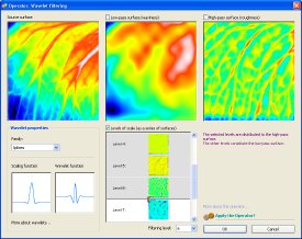
The Wavelets optional module makes it possible to carry out multi-scale analysis on profiles and surfaces in order to detect the scale on which phenomena occur. ISO 16610 spline wavelets as well as other advanced wavelet families are available. The user can visualize profiles and surfaces at each scale before selecting the boundary between high-pass roughness scales and low-pass waviness scales.
The Lead Analysis (Twist) optional module implements 2nd generation lead analysis in the automotive industry in accordance with Mercedes-Benz Engineering Standard (Measurement and Evaluation Method for the Assessment of Lead-Reduced Dynamic Sealing Surfaces, 2009).
The Image Co-Localization optional module that co-locates images from different instruments (for example AFM images with fluorescence images or confocal microscope topography images with SEM images) has been extended with several new options.
Numerous other new features in MountainsMap 6.1 include easier parameter selection, streamlined extraction of sub-surfaces for independent analysis, more precise line by line correction of anomalous scan lines, extended visualization of correlations between multi-channel topography, color and intensity images, enhanced force curve analysis and new contour parameters. The addition of Brazilian Portuguese brings the number of languages supported by MountainsMap to ten.
"MountainsMap 6.1 provides much greater openness, faster calculation and new surface analysis features for a wide range of surface metrology applications in materials research, industry and the life sciences," stated François Blateyron, Chief Operations Officer of Digital Surf. "Users of MountainsMap 6.0 can benefit from a free update and there is a straightforward upgrade path for users of earlier versions of MountainsMap software."