Apr 22 2014
A geostatistical approach for studying environmental conditions in stream networks and landscapes has been successfully applied at a valley-wide scale to assess headwater stream chemistry at high resolution, revealing unexpected patterns in natural chemical components.
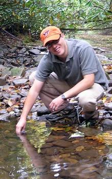
 Researcher Kevin McGuire takes a water sample from a forest stream. Credit: Virginia Tech
"Headwater streams make up the majority of stream and river length in watersheds, affecting regional water quality," said Assistant Professor Kevin J. McGuire, associate director of the Virginia Water Resources Research Center in Virginia Tech's College of Natural Resources and Environment. "However, the actual patterns and causes of variation of water quality in headwater streams are often unknown."
"Understanding the chemistry of these streams at a finer scale could help to identify factors impairing water quality and help us protect aquatic ecosystems," said Gene E. Likens, president emeritus and distinguished senior scientist emeritus with the Cary Institute of Ecosystem Studies and the University of Connecticut.
Results of the study that used a new statistical tool to describe spatial patterns of water chemistry in stream networks are published in the April 21 issue of the Proceedings of the National Academies of Science by a team of ecosystem scientists, including McGuire and Likens.
The data used in the new analysis consist of 664 water samples collected every 300 feet throughout all 32 tributaries of the 14-square-mile Hubbard Brook Valley in New Hampshire. The chemistry results were originally reported in 2006 in the journal Biogeochemistry by Likens and Donald C. Buso, manager of field research with the Cary Institute.
McGuire and other members of the National Science Foundation's Long-Term Ecological Research team at the Hubbard Brook Ecosystem Study decided that the huge, high-resolution dataset was ideal for a new statistical approach that examines how water flows both within the stream network and across the landscape.
"The goal was to visualize patterns that no one has been able to quantify before now and describe how they vary within headwater stream networks," said McGuire. "Some chemical constituents vary at a fine scale, that is patterns of chemical change occur over very short distances, for example several hundred feet, but some constituents vary over much larger scales, for example miles. Several chemical constituents that we examined even varied at multiple scales suggesting that nested processes within streams and across the landscape influence the chemistry of stream networks."
"The different spatial relationships permit the examination of patterns controlled by landscape versus stream network processes," the article reports. Straight-line and unconnected network spatial relationships indicate landscape influences, such as soil, geology, and vegetation controls of water chemistry, for instance. In contrast, flow-connected relationships provide information on processes affected within the flowing streams.
The researchers are very familiar with the Hubbard Brook Valley and could point to the varying influences of the geology and distinct soil types, including areas of shallow acidic organic-rich soils.
The findings revealed by the analysis technique showed how chemistry patterns vary across landscapes with two scales of variation, one around 1,500 feet and another at about 4 miles. However, when chemistry patterns were examined only in the downstream direction, there was predominantly one scale of variation, which was less than about 1 mile.
The journal article concludes, "This spatially explicit, network-level analysis is crucial to refining long-held assumptions and stream structure and function."
"One assumption that is typical in streams is that the chemical variation is controlled primarily by the way in which water flows in streams, which would cause gradients or patterns that are strongly oriented downstream," said McGuire.
"Of course we found that to be the case; however, we were able to show that patterns affected different dissolved chemical elements at different scales, or distances, along the stream network," he continued. "In addition to downstream gradients, we show that there were also 'patches' of variation in the patterns of dissolved chemicals that were caused by processes related to the watershed or landscape.
"In other words, natural chemical variation is not just influenced by the flow accumulation in rivers but processes operating within the landscape or watershed that affect the gradual downstream variation in chemistry, which is probably intuitive to most, but has never been quantified at both the fine scale and broad valley-wide extent as examined this study," McGuire said.
"It really highlights the complexity of spatial patterns in stream networks, particularly in these small headwater streams that aggregate to create larger rivers that we all depend on for ecosystem services," he said. "Understanding the natural variation of water chemistry in these headwater regions may help watershed managers choose better monitoring sites or at least be able to better interpret monitoring data and more efficiently track changes in water quality as land use and climate conditions change."